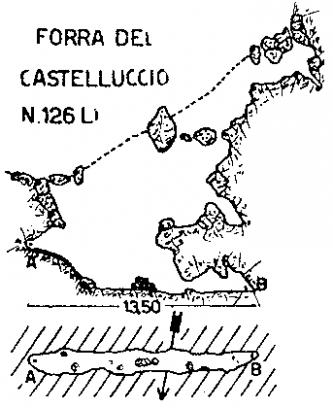
Name
Forra del Castelluccio
Insertion date
2006-10-16 15:31:34
Date updated
2006-10-27 21:28:34

Type of cavity
grotta
State
Italy
District
218
City
Genova
Area Speleological
Monte Antola
Number cadastre
126 LI/GE
Length amount
13
Unevenness
10 m
Groups
G.S.L. A. ISSEL
Longitude
8°59'33.6'' E
Latitude
44 27' 33.6'' N
Datum
WGS84
Altitude
290 m slm
Cart1

Lat:44.45933333N Lon:8.99266667E Datum:WGS84
| Comments : |
| You must be registered to Openspeleo to post a comment |
 Go to the contents list
 Previous record
 Next record
 View
View